
Ficheiro:Le Castellet circuit map Formula One 2018 without corner names English 29 06 2021.svg

Tamaño desta vista previa en PNG do ficheiro en formato SVG: 673 × 599 píxeles. Outras resolucións: 270 × 240 píxeles | 539 × 480 píxeles | 863 × 768 píxeles | 1.150 × 1.024 píxeles | 2.300 × 2.048 píxeles | 2.191 × 1.951 píxeles.
Ficheiro orixinal (ficheiro SVG; resolución de 2.191 × 1.951 píxeles; tamaño do ficheiro: 59 kB)
| Este ficheiro procede de Wikimedia Commons. A continuación móstrase a información da súa páxina de descrición. Commons é un repositorio libre de ficheiros multimedia. Pode contribuír alí cargando as súas imaxes. |
Resumo
| Descrición |
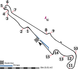
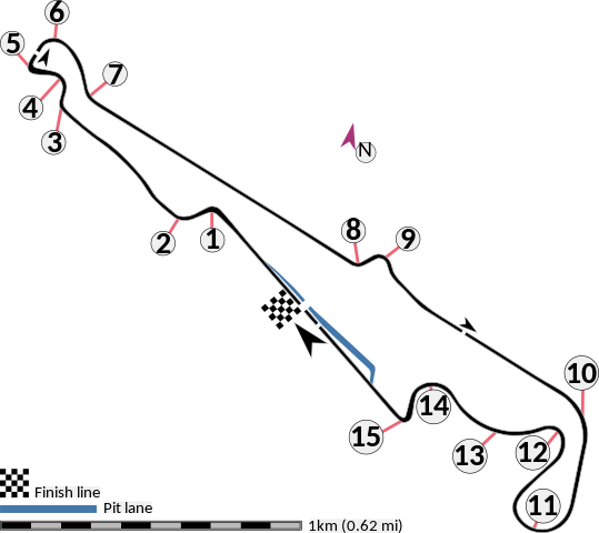
English: This is an altered version of File:Le Castellet circuit map Formula One 2018 without corner names June 2021.svg with the key solely in English and a few other alterations. This is a map of the Le Castellet motor circuit as it was used by w:en:Formula One for the w:en:2018 French Grand Prix, before the pit lane entrances and exits were reconfigured, and includes corner numbers and other information sourced from the FIA's map of the circuit. This map is valid for races which use this layout and corner numbering scheme, please upload a new file for races which use different layouts or corner numbering schemes rather than replacing this file. As this is a free-hand map drawn by an enthusiast rather than a professional cartographer's work it may contain some errors, although checking it against other maps it appears accurate enough for most purposes. The track is shown in black with a grey outline, while the pit lane is shown in blue. A scale showing the length of one kilometre (with increments of 100 metres) is given, to allow viewers to contextualise and understand what they are looking at. Corner numbers and other important text is given an off-white background to avoid transparency issues rendering it illegible on certain devices. A thick white line covering the track and the pit lane, marked with a chequered flag, shows the location of the start/finish line, also known as the control or timing line. A thinner white line, covering only the track, shows the location of pole position, and is marked with a large black arrow indicating the direction of travel. There are also thin white lines crossing the track which indicate the ends of the first and second timing sectors used by Formula One; these are marked with smaller black arrows, which also indicate the direction of travel. The mauve arrow marked "N" shows the direction of north.
Arrow pointing north Pit lane Links corner number to location of corner |
| Data | |
| Orixe | Obra propia |
| Autoría | HumanBodyPiloter5 |
| Outras versións |
   |
Licenza
Eu, como posuidor dos dereitos de autor desta obra, pola presente publícoa baixo a seguinte licenza:
| Este ficheiro está dispoñible baixo a licenza Creative Commons de renuncia universal ao dominio público 1.0. | |
| A persoa que asociou unha obra con este documento, deu a obra ao dominio público renunciando a todos os seus dereitos sobre ela en todo o mundo baixo as leis de dereitos de autor e relacionadas ou dereitos legais derivados que tiña sobre a obra, na medida permitida pola lei. Pode copiar, modificar, distribuír e empregar esta obra, mesmo para fins comerciais, sen necesidade dun permiso por parte do autor.
|
Historial do ficheiro
Prema nunha data/hora para ver o ficheiro tal e como estaba nese momento.
| Data/Hora | Miniatura | Dimensións | Usuario | Comentario | |
|---|---|---|---|---|---|
| actual | 29 de xuño de 2021 ás 01:15 | | 2.191 × 1.951 (59 kB) | HumanBodyPiloter5 | Uploaded own work with UploadWizard |
Uso do ficheiro
A seguinte páxina usa este ficheiro:
Uso global do ficheiro
Os seguintes wikis empregan esta imaxe:
- Uso en af.wikipedia.org
- Uso en en.wikipedia.org
- Uso en fi.wikipedia.org
- Uso en fr.wikipedia.org
- Uso en fy.wikipedia.org
- Uso en hr.wikipedia.org
- Uso en hu.wikipedia.org
- Uso en id.wikipedia.org
- Uso en it.wikipedia.org
- Uso en pl.wikipedia.org
- Uso en ro.wikipedia.org
- Uso en tr.wikipedia.org